


NAVER Map Evolves with Spatial Intelligence Technology, Launches “Indoor AR Navigation,” Now Offering Precise Directions Even Indoors
NAVER Map Evolves with Spatial Intelligence Technology, Launches “Indoor AR Navigation,” Now Offering Precise Directions Even Indoors
“More Precise and Realistic Experience—From Place Discovery to Navigation with 3D Maps”
NAVER Map Evolves with Spatial Intelligence Technology, Launches “Indoor AR Navigation,” Now Offering Precise Directions Even Indoors
- NAVER Map enhances synergy with NAVER LABS’ spatial intelligence technology, introducing indoor AR directions and Flying View 3D, following Street View 3D
- AR navigation integrates digital twin and AI-based visual localization technologies, first applied at Seoul’s COEX, with expansion to more facilities planned
- Flying View 3D, which vividly renders major landmarks across Korea in 3D, also unveiled
October 23, 2025
Following last year’s launch of “Street View 3D,” NAVER Map accelerates its innovation in service experience with the newly unveiled “Indoor AR Navigation” and “Flying View 3D,” powered by NAVER LABS’ spatial intelligence technology.
NAVER Corporation (CEO Choi Soo-yeon) announced on October 23 that it has officially launched the “Indoor AR Navigation” service, which enables users to receive accurate directions via NAVER Map, even in indoor spaces without Global Positioning System (GPS). The company also introduced “Flying View 3D,” a feature that renders major landmarks across Korea in 3D.
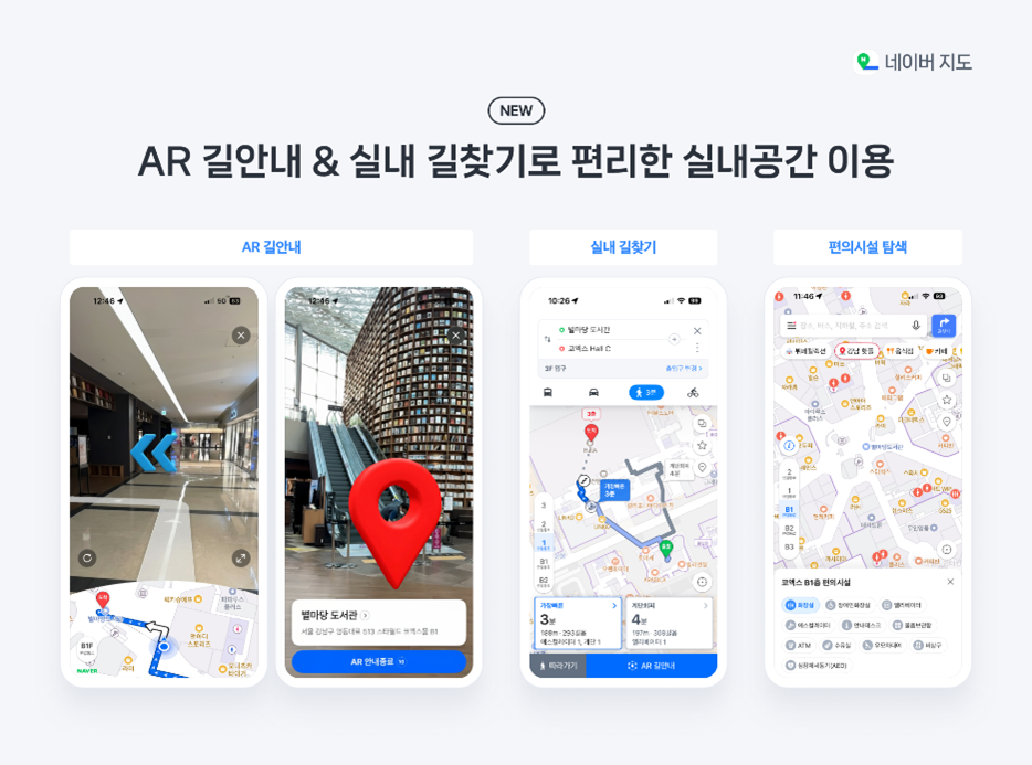
Indoor AR Navigation is a service that provides augmented reality (AR)–guided directions by accurately recognizing a user’s location and orientation with just a smartphone camera, even in areas where GPS signals are unavailable. When users scan their surroundings with the camera, directional guides to their destination are intuitively overlaid onto the real-world environment, enabling easy navigation even in complex indoor spaces, such as large-scale commercial facilities. With this update, NAVER has also improved the UI for indoor amenities, making it easier for users to find not only restaurants and cafés but also elevators, restrooms, and information desks. This is expected to further enhance convenience by enabling users to easily locate their destinations through AR navigation.
To provide precise directions even indoors, NAVER Map has advanced its service by incorporating a range of spatial intelligence technologies developed by NAVER LABS. Notably, it applies digital twin technology, which builds 3D spatial data, and AI-based visual localization, which accurately identifies a user’s current position using a smartphone camera. Even as users move in real time, the system precisely tracks their location and viewing direction without error, naturally augmenting diverse information, such as restaurants, cafés, and stores, in the camera view, resulting in the delivery of accurate and immersive guidance within indoor spaces.
Indoor AR Navigation first became available at the Convention and Exhibition Center (COEX). Since August, NAVER Map has been piloting the AR navigation service at NAVER 1784 and Green Factory to enhance its technology and service stability. Starting with COEX, NAVER Map plans to gradually expand the service to other high-foot-traffic, multi-use indoor complexes.
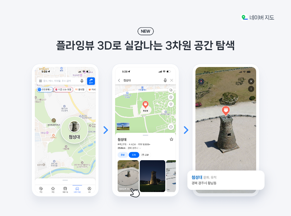
NAVER Map has also introduced the “Flying View 3D” service, which enables more vivid exploration of major landmarks across Korea. The feature will be first released in 10 locations, including Gyeongju’s Cheomseongdae Observatory, Seoul’s COEX, Incheon’s Songdo Central Park, Jeonju’s Hanok Village, and Busan’s BEXCO. NAVER Map plans to expand Flying View 3D to additional iconic landmarks and their surrounding areas. The service is also expected to enhance the travel experience of international visitors to Korea by allowing them to explore major attractions with a heightened sense of realism through NAVER Map.
When loading Flying View 3D, users can also experience highly immersive footage powered by NAVER LABS’ Novel View Synthesis (NVS) technology. NVS is a 3D vision technology that reconstructs 3D spaces through image-based learning alone and generates footage that appears to be captured from multiple angles. By combining high-resolution aerial images taken by drones with Street View 3D images captured using NAVER LABS’ proprietary mapping device “P1,” the service allows users to realistically explore 3D-rendered landmarks from various angles.
Choi Seung-Lak, Head of NAVER Map Services, stated, “NAVER Map is evolving beyond an all-in-one platform that supports the entire user journey from place discovery to navigation into the ‘map closest to reality,’ one that vividly recreates the offline experience.” He added, “Given the boundless synergy between maps and spatial intelligence technology, we will continue exploring diverse ways to deliver even more innovative service experiences to users.” (End)